Other
Borough Towns and Villages
AGHALEE
An attractive village in the centre of the agricultural country
bordering Lough Neagh, Aghalee stands on the Lurgan to Crumlin road
and has in recent years grown as a 'dormitory' village for both
Lurgan and Lisburn. The village was the birthplace of the famous
portrait painter, Sir John Lavery. Close to it runs the line of the
old Lagan Navigation Canal.
Although it retains its agricultural links, Aghalee is a growing
village and both public and private houses are being built.
BALLINDERRY AND LOUGH NEAGH
Ballinderry, which has been called Ulster's 'Garden of Eden', stands
in the rich dairy farming area on the eastern side of Lough Neagh.
This was once a land covered with oak forests from whose trees the
timber for many naval ships was provided; the name 'Ballinderry'
(Townland of the Oaks) is a direct reference to this fact. With its
oak and apple trees this is still a very wooded part of Ulster and
is famous, too, for its onions�the expression 'as strong as a
Ballinderry onion' is well known throughout the area.
The area is rich in old buildings particularly in
the villages of Upper and Lower Ballinderry although at the latter
new houses and a school have been completed. At Portmore is the ruin
of the original church of St. Loo where Jeremy Taylor preached those
gentle exhortations which are immortalised in his books 'Holy
Living' and 'Holy Dying'. Jeremy Taylor planned the Middle Church
(although he died before it was completed) which has an exquisite
interior that is the very essence of the 17th century. The high
backed pews and the three decker pulpit are very fine. Also of merit
is the Moravian Church which was founded in 1750 by John Cennick, a
great English preacher who was of Bohemian descent.
Between Ballinderry and Lough Neagh is Portmore
Lough (otherwise known as Lough Beg) and here, as well as Jeremy
Taylor's church, was the great castle built in 1664 by Lord Conway.
The castle had massive stables, 140 feet long, 35 feet wide and 40
feet high capable of stabling two troops of horse. After Conway's
death, castle and stables fell into neglect and were finally removed
in 1761. The deerpark, once stocked with deer and wildlife of all
kinds, was then given over to farming.
Lough Neagh, one of the most attractive features of
this part of Ulster, is the largest fresh water lake in the British
Isles. Its waters are said to have the power of petrifying wood;
more important, however, is its fishing for here the pollan � or
fresh-water herring � is found in large numbers. Eels too, are
plentiful as are such coarse fish as pike, roach and perch.
Along the shores of the Lough are numerous picnic
spots and bathing areas � Sandy Bay, for example, is a delightful
corner. Regarded as an expansion of the Bann Valley, the Lough has
several legends to explain its existence. Most popular and
colourful is that Finn McCool, the giant of the Giant's Causeway,
formed the Lough by simply grabbing up a lump of Irish soil and
hurling it into the Irish Sea. The space left behind formed Lough
Neagh whilst the lump of soil formed the Isle of Man! The two
features are, in fact, more or less the same size.
The Lough has always attracted tourists and has
often been written about. Many years ago the Rev. George Hill wrote
these lines, with the thought in his mind of the many immigrants
forced to leave this area:
Lough Neagh they used at close of day
Along thy silent strand,
To watch the sun set far away,
O'er old Tir-Eoghan's land;
The fading light how like the flight
Of hope from lnlsfail
From holy hill so green and bright
From haunted wood and vale.
And often were their children told
Of Lough Neagh's silent strand,
And of the sunset, spread like gold
On old Tir-Eoghan's land.
Lough Neagh's one island is Ram's Island, less than
a mile long, heavily wooded and with a ruined round tower upon it.
Roughly equidistant from Ballinderry and Glenavy, the island is
celebrated in this verse:
'Tis pretty to be in Ballinderry,
'Tis pretty to be in Aghalee;
But prettier far on Little Ram's Island
Trysting under the ivy tree.

CULCAVY
One mile to the west of Hillsborough, Culcavy was first developed as
a distilling centre close to the Lagan Navigation Canal and that
waterway provided its raw materials. During the 19th century
distilling was replaced by the woollen industry which, in turn, was
superseded by the weaving of linen. The place is still a small
industrial settlement and plans are in hand to provide new
industries.
DROMARA
A busy little town in the south of the Borough, Dromara nestles in
the hilly country which rises to the beautiful Dromara Mountains
whose highest peak is Slieve Croob (1502 feet). This was, at one
time, Magennis territory but it passed into the ownership of the
Downshire family who built a market house in the town. The River
Lagan rises on the northern side of Slieve Croob and runs swiftly
through the town.
Although Dromara now grows in favour as a centre from which to
explore this beautiful countryside, the place was for long almost
unknown � largely explained by the fact that Dromara was by-passed
by roads and railways serving the larger towns all around. For those
who know where to explore this area there is much to enjoy. The
beautiful countryside can be surveyed in panoramic splendour from
the Rib and Windy Gap roads which climb up over the mountains
towards Castlewellan and beyond. Local farms are small and are often
farmed by men who also work at other jobs� a reminder that Dromara
was once the centre for flax growing and of its preparation for the
linen mills. The ending of the linen industry here meant that no
longer was there an industry to employ large numbers of people. Many
people left the Dromara area but others turned to a 'dual role' of
farming allied to another occupation.
Dromara's houses huddle in their valley beside the Lagan spanned by
an old and rather beautifully weathered stone bridge. Of great
interest are two fine churches which are both of architectural and
historic merit. St. John's Church (Church of Ireland), although
ancient, was rebuilt in 1811 and again in 1894 when the transepts
were added to make it cruciform in plan. Recent restorations have
greatly enhanced the beauty and comfort of the church. The organ is
of note, it was built in 1907 by Megahey of Cork and was electrified
and rebuilt fifty years later. Of great beauty is the James Pollock
Memorial Window which was installed in 1974 in memory of that man's
sixty years of service as church organist.
The other church here is the First Dromara Presbyterian Church.
Built in 1826 it was a typical barn of a building (known as the big
meeting house) erected on Artana Hill overlooking a wide countryside
with views extending as far as Black Mountain and Cave Hill. The
church has been remodelled in recent years and has modern pews. It
has, like St. John's, a hall attached to it�both are features of the
last twenty years or so.
DRUMBO
A farming village amid the fields and winding lanes that lie between
the Lagan and the southern part of the Borough, Drumbo is known for
its ancient round tower, the only one left in Down. Indeed there
were formerly three such towers here but now only the stump of one
remains resembling a windmill tower. It stands behind the
Presbyterian church, a building that dates from 1882. There are
several large estates in the Drumbo area including those of
Belvedere and Trench House which lie quite close to the village. New
Housing Executive dwellings have been built recently in Drumbo.
DRUMBEG
One of the parishes on the southern edge of Belfast, Drumbeg (whose
name means 'Little Edge') is basically a residential community and
one that has in many ways not changed a great deal since 1846 when
an entry in the Parliamentary Gazetteer said of it: -
"It is rich in those features of landscape which
possess beauty without grandeur and picturesqueness without
power. Villas are so numerous, both within and immediately
beyond the limits, as almost to melt into one another, and form
a pervading or general feature of the charming scenery."
The tower of the parish church of St. Patrick dates
from 1798 but the spire is later (1833) as is the rest of the church
which was rebuilt in 1870. The bells, however, like the tower date
from the preceding building on the site and were cast in 1685. The
church's lych-gate is a very handsome one.
The village stands next to the Lagan and at Drum
Bridge the Council maintains a car park which has direct access to
the river's tow path.
DUNDROD
On the road from Lisburn to Antrim and Belfast Airport, Dundrod is a
small village in the rather level country between Lough Neagh and
the Belfast Hills. Some residential development has taken place but
basically Dundrod consists of its original centre grouped around the
church, church hall, school and post office. The Borough Council,
however, owns the pits area at the Ulster Grand Prix circuit and it
is expected that improvements will be made over the next few years.
This racecourse is one of the most famous in the world. The major
race, the Ulster Grand Prix, draws crowds of spectators from many
countries.
DUNMURRY
Another of Belfast's southern outposts, Dunmurry, is situated along
the Belfast to Lisburn road and has in recent years grown enormously
as private and public housing estates have been built. The
population is now equal to that of a town and Dunmurry has its own
shops, schools, churches and other
modern amenities.
Backed by the lovely Collin Mountain, with its
famous Collin Glen, Dunmurry is flanked by the River Lagan which,
although canalised, still retains the atmosphere of a quiet rural
waterway. All around Dunmurry's housing estates are the pleasant
open landscapes which include the golf course, the Antrim Hills,
Moss Side and the Lagan Valley. There are also extensive playing
fields in and around Dunmurry.
Close to Dunmurry is the smaller village of
Derriaghy, an attractive place, whose parish church is of interest.
The church registers here date from 1696, unusually old for Ulster.
EDENDERRY
Also close to the southern border of Belfast is Edenderry, a village
beside the Lagan Canal which cuts a straight path across the
countryside past the estate of Edenderry House. Here is Shaw's
Bridge, well known to artists and photographers for this is one of
the more beautiful stretches of the canal, a waterway that was built
between 1754 and 1764 from funds gathered by a local tax on ale and
whiskey sales. Although a pint of porter then sold for only twopence
a total of �70,000 was amassed for the Lagan Canal scheme.
Beside the canal is the famous linen mill around
which, in the 19th century, the village grew up. The mill itself was
built on the site of an older linen bleach-green. The rows of
red-brick terraced houses for the mill workers overlook the mill and
the Lagan.
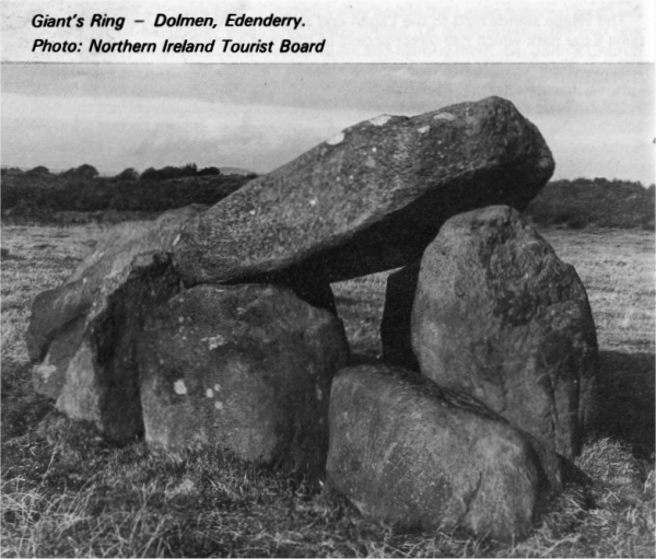
Just outside Edenderry is the Giant's Ring, a most
important pre-historic relic that was probably constructed about
four thousand years ago. Its 15 foot high ramparts form a regular
circle 250 yards in diameter and there are superb views across the
Lagan valley. The circumference is composed of seven sections and at
the centre stands a dolmen of seven great stones supporting one more
in table form, all of basalt.
GLENAVY
On the eastern side of Lough Neagh, Glenavy stands at the junction
of roads to Belfast, Lisburn, Antrim and Moira, and is on the
Glenavy river which enters the Lough opposite Ram's Island and close
to Sandy Bay.
Glenavy has had a long history and until the 17th
century was called 'Lanaway' from 'Lann-Allaich' (the church of
the dwarf), the dwarf in question being a priest who was installed
by St. Patrick to look after the parish. Also of historic note is
Crewe Hill, (629) feet where the ancient kings of Ulidia (Eastern
Ulster) were crowned. Brian Boru and his Munstermen used to visit
this site to exchange gifts with their Ulster counterparts.
HILLHALL
This is a small and scattered village whose houses, church, school
and two factories are spread out along part of the former Belfast to
Lisburn turnpike road not far distant from Drumbo.
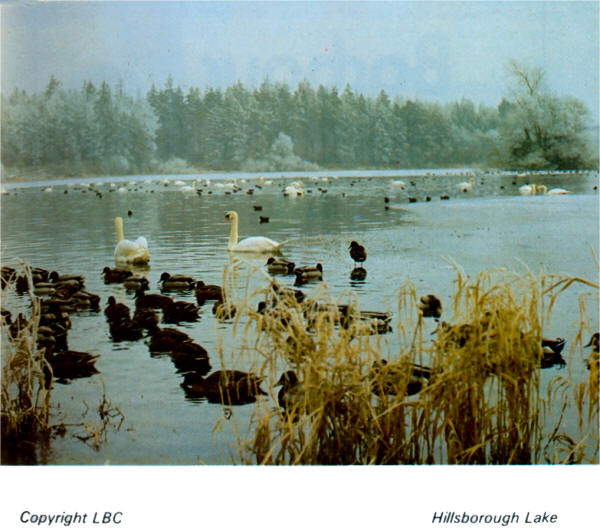
HILLSBOROUGH
A small and delightful town, Hillsborough stands south of Lisburn on
the main Belfast to Dublin road and is an almost entirely unspoilt
18th-19th century town, a visual joy to the lover of good
architecture. The town, in fact, received its charter of
incorporation in 1661 but was laid out in the first half of the 18th
century and Hillsborough has a rare wealth of Georgian buildings.
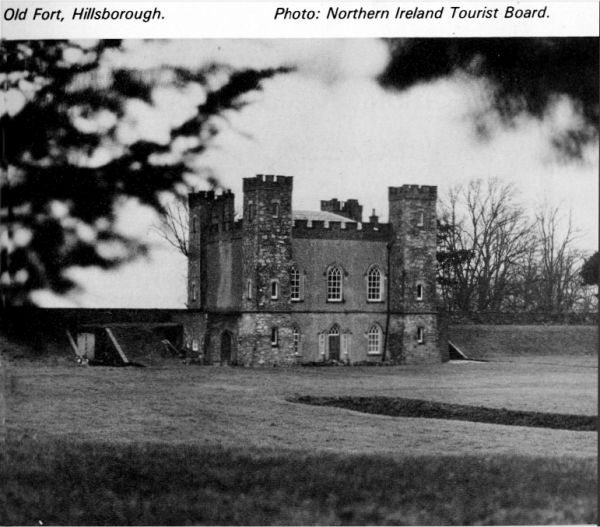
The town takes its name from Sir Arthur Hill who, in
about 1650, built Hillsborough Fort which, with its eight foot high
earth ramparts and stone revetments looks proudly out over the town.
King Charles the Second made this a royal fortress and Sir Arthur
was constable with twenty warders. The fort commanded the strategic
pass of Kilwarlin and was used in 1690 by William the Third on his
way to the Battle of the Boyne. The room in which he slept re-mains
today. The gatehouse is an impressive rectangular two-storey
structure of rubble masonry with brick dressings and battlements and
tall square corner towers. The Fort was given to the State by the
Downshire family (the Hill family later became the Downshires) in
1959 but it is not open to view.
In the town centre is the Market house, a charming
building of three blocks pyramidally arranged. The ground floor, on
a granite plinth, has a nine bay frontage with round open arches in
the central block and round-headed windows in the pyramidal roofed
blocks; the central square block of three bays rises another storey.
Above rises a square clock tower with ornamental urns, cupola and
banner weathervane.
Extremely fine is the parish church of St. Malachy,
built in 1636 and restored in the 18th century by Wills Hill (later
the First Marquis of Downshire). Wills Hill had hoped his church
would be afforded cathedral rank but here he was disappointed.
Superbly sited on a hillside off the main street and
near Hillsborough Fort, the church is approached along an avenue of
lime trees interspersed with rhododendrons. Close to the church, and
now leading to the churchyard, is a rather curious pinnacled gateway
that may be a surviving fragment of the earlier church of 1636. Also
close to the church is a memorial, carved by Rosamund Praeger, to
the composer Hamilton Harty. Externally the notable feature of the
church is its three-storey tower capped by pinnacles set at the
corners with, from the centre a soaring needle of a spire.
Internally the church is largely unspoiled (although altered in 1898
by Sir Thomas Drew) and is notable for the quality of its woodwork,
which include the high oak pews, the tall octagonal pulpit with
sounding board, the bishop's throne and the two organs - a small
instrument of 1795 by George Pike England and a more massive John
Snetzler organ of 1773.
Also of rare interest is the Sexton's House and
Parish Room with, at each end, a low pavilion capped by Gothic
spirelets. Both were originally school houses - for boys and girls
respectively.
Yet another of Hillsborough's notable buildings is
the Castle, standing in a large and beautiful park, and formerly
Government House. This is a pleasing though not over-impressive two
storey house that was completed in 1797 to the designs of R.F.
Brettingham. It incorporates a few fragments of a far smaller house
that was built in 1760. In the 1830s and 1840s the house was much
enlarged and extensively remodelled.
Much of the credit for Hillsborough's layout and
design must go to Wills Hill, the first Marquis of Downshire. He was
a quite remarkable man and greatly appreciative of the Georgian
style of architecture. Previously the surrounding area had been
controlled by the Maginesses for centuries. The village was then
called Cromlyn and to it as English 'Planters' came the Hill family.
The first to arrive was Moyses Hill who came with the army of
Elizabeth the First. He married the sister of Sorley Boy MacDonell
and settled in the village. His son, Peter, strengthened the old
castle and then, after ousting the Maginess family, built the fort.
The Hill family fortunes grew and by the end of the 17th century (by
which time they had called the place after themselves) were among
the richest families in the British Isles.
The town today has a quality unique in Ulster and
the re-routing of the main Belfast to Dublin road around
Hillsborough should help further to preserve its character and
qualities. One modern building of note is the Lisburn Borough
Council's main administrative block which, in Georgian style, was
built on the site of the 18th century Downshire Hotel which was
burnt down in 1943. There are extensive public and private housing
estates near Hillsborough and it is planned to build more houses and
light industrial premises.
LAMBEG
On the eastern side of Lisburn, Lambeg stands on the road and rail
routes to Belfast and on the River Lagan which here, with its
pleasantly wooded banks, is in one of its most attractive reaches.
Here, too, is the line of Lagan Navigation Canal although it is now
out of use and its locks are neglected and overgrown. Overlooking
the village is the 620 foot height of White Mountain, a noted local
landmark and a southern outpost of the Belfast Hills. From its
summit fine views can be had to the Mourne Mountains.
Lambeg grew up around the local linen industry and
it has developed industrially and residentially in recent years. The
Lambeg Industrial Research Association has its headquarters and
laboratories here and these have been in the forefront of all new
textile developments and processes in Ulster. Lambeg was also once
famous for its drums and for the rallies of Orangemen and their
characteristic drumming parties. The largest drum was referred to as
a Lambeg Drum and to beat a tattoo on it was to "beat a Lambeg".
This Lambeg Drum can still be seen in Orange Order processions.
MAGHABERRY
This village stands between Lisburn and Moira just north of the
Belfast railway. A new prison is at present under construction close
to Maghaberry and this is expected to lead to further developments
in the village during the next five years. At nearby Magheragall is
a handsome Presbyterian church and an older parish church whose
chancel contains several features of interest.
MAZE
Also situated between Lisburn and Moira, the village of Maze stands
on the Lagan's southern bank. The village is noted for the Down
Royal Racecourse, the oldest in Ireland and the venue, each July,
for the Ulster Harp Derby. Other important races take place
throughout the year. The racecourse belongs to a very old
established association, "The Down Royal Corporation of
Horsebreeders" who were founded in 1685 by a Royal Charter that was
granted by James the Second for the "improvement of horse breeding
in the County of Down".
The Maze racecourse draws crowds from Belfast at race times and the
village becomes very busy. The racecourse is on the south side of
the village centre; to the north of it is Lissue, a small hamlet
with the Lissue Hospital as the principal building.
MOIRA
West of Lisburn and at the western extremity of the Borough, the
small town of Moira stands on the main road and rail
routes
from Belfast and Lisburn to Portadown.
 Once known as Magh Rath (the plain of the fort), Moira has long been
a place of importance and a fierce battle took place here between
the native people and Danish marauders who ravaged the countryside
during their incursions from Lough Neagh to which they had gained
access by way of the River Bann from Coleraine. Until the 17th
century the land in this area belonged to the O'Lavreys but it
passed, in that century, to George Rawdon from Yorkshire and to him
and his family is owed the credit for the planning and building of
Moira. The Rawdon family were, in fact, land agents to the Second
Viscount Conway and Killultagh who came also from Yorkshire - from
Otley in the West Riding. Once known as Magh Rath (the plain of the fort), Moira has long been
a place of importance and a fierce battle took place here between
the native people and Danish marauders who ravaged the countryside
during their incursions from Lough Neagh to which they had gained
access by way of the River Bann from Coleraine. Until the 17th
century the land in this area belonged to the O'Lavreys but it
passed, in that century, to George Rawdon from Yorkshire and to him
and his family is owed the credit for the planning and building of
Moira. The Rawdon family were, in fact, land agents to the Second
Viscount Conway and Killultagh who came also from Yorkshire - from
Otley in the West Riding.
The family built a huge mansion in a beautiful
demesne on the edge of Moira and the extensive gardens were
beautified by Sir Arthur Rawdon with rare plants and trees brought
from the West Indies. In 1761 Sir John Rawdon became the Earl of
Moira but later all his property passed to the Batesons, a family
that afterwards became Lords of Deramore. The house has long since
gone but the Moira demesne, after years of use as pasture land, is
now a public park.
Before 1722 Moira was in the parish of Magheralin
but in that year it was made a parish in its own right and shortly
afterwards a monthly market was started, to promote the linen trade
and to sell general produce. Although this market is no longer held,
Moira keeps its importance as a commercial centre. The town has
expanded, too, as a residential area with extensive estates of both
public and private houses.
Moira's broad main street was laid out on the slope
of a hill in the 18th century and it has, with adjacent
thoroughfares, a close knit character of distinction. A notable
building is the Town Hall which, although no longer serving civic
needs, still retains its air of solidarity and dignity. A wall of
the former Moira Castle and the remains of ornamental ponds nearby,
is all that survives of the former magnificence of the Rawdons. The
house was pulled down in 1870 but the 40 acre demesne, as previously
mentioned has been developed as a public park. A transit caravan and
camping park is but one of its new amenities.
The First Presbyterian Church was built in 1860 but
much older is St. John's parish church which was started in 1722 and
whose architectural lines blend with the 18th century houses of
Moira from which it stands apart. The Georgian elegance of the
church is enhanced by the tall copper-clad spire. Of interest within
is the ancient reredos with the creed inscribed thereon in gold
letters whilst the communion rails are said to have come from the
demolished castle.
Moira also has numerous other 18th century buildings
of interest including one opposite the Market House that dates from
1735. The Chantry School, used for services before the church was
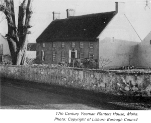
built, is even older and, on the edge of the town is Berwick Hall, a
typical two-storey thatched Yeoman 'Planters' house of about 1700.
Many other 18th century houses were built for letting and can be
distinguished by their arched carriage recesses.
Moira has several industries including a poultry
processing plant which provides substantial employment and on the
outskirts of the town is a lime works.
Not far distant is Soldierstown, a village close to
Broad Water, the header reservoir for the Lagan Navigation Canal.
The canal's engineer, Richard Owen, is buried in the nearby Church
of Ireland graveyard.
PLANTATION
Close to the Lisburn motorway interchange, the village of Plantation
originally consisted of a cluster of workers' houses alongside the
bleachworks and warehouse that were set up in the 18th century by
John Barbour who introduced thread making to this area. Of the
original settlement which, by its name, presumably dated from the
days of the Planters, little or nothing now survives.
RAVARNET
North east of Hillsborough is Ravarnet, a small residential
community that developed in the 19th century alongside its weaving,
corn and flax mills. Unfortunately, much of the weaving mill site is
now derelict although the actual building is used for the storage,
baling and distribution of waste paper.
STONYFORD
At the centre of several by-roads, Stonyford stands south of Dundrod
in the level country between the Belfast Hills on the one hand and
Lough Neagh on the other. This is a natural collecting area for
water and the large reservoir here is popular with anglers. The
village itself is small and pleasantly rural and there are no plans
for immediate development in the area.
|